|
Climate variability in the Karakoram Region |
This work has been performed in collaboration with David Archer (JBA Consulting) and published in:
Archer, D.R. and Fowler, H.J. 2004. Spatial and temporal variations in precipitation in the Upper Indus Basin, global teleconnections and hydrological implications. Hydrology and Earth System Sciences, 8(1), 47-61. [Abstract]
Fowler, H.J. and Archer, D.R. Conflicting signals of climatic change in the Upper Indus Basin. Journal of Climate, 19(17), 4276–4293. [Abstract]
See this web site for a nice layman's summary of the results from this work.
The mountainous region of the Upper Indus Basin (UIB) stretches from the Hindu Kush Range on the borders of Afghanistan through the Karakoram Range to the western margins of the Tibetan Plateau and Himalayas (Figure 1)
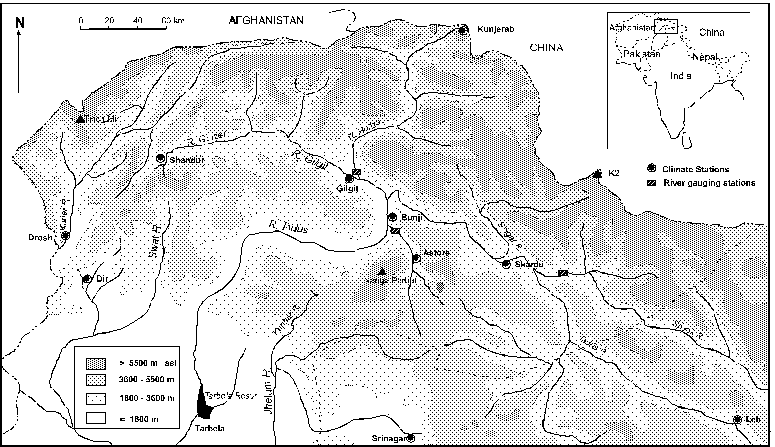
Figure 1 The Upper Indus Basin and surrounding region, showing rainfall stations used in analysis and river networks with an underlying elevation map.
Most of the flow in the River Indus is derived from melting snow and glaciers. Climatic variability, through change in both precipitation and energy inputs, will impact upon water availability and thus rural livelihoods. Over the period 1961-99 there were significant increases in winter, summer and annual precipitation (Table 1). It is likely that these changes are related to a strengthening of the winter North Atlantic Oscillation index, particularly since the 1980s (Table 2).
Table 1 Trend in precipitation from 1961-1999 for annual and by 3 and 6-month periods showing change per decade as a percentage of the period average.
|
Station |
J-D |
J-M |
A-J |
J-S |
O-D |
O-M |
A-S |
Drosh |
−1 |
+3 |
−8 |
−7 |
+6 |
+4 |
−8 |
|
Gilgit |
+10 |
+1 |
+9 |
+5 |
+11 |
+3 |
+8 |
|
Bunji |
+13 |
−7 |
+10 |
+19 |
+23 |
+4 |
+14 |
|
Astore |
+5 |
+3 |
−3 |
+18 |
+16 |
+5 |
+3 |
|
Skardu |
+14 |
+18 |
+3 |
+17 |
+19 |
+18 |
+8 |
Srinagar |
+1 |
+3 |
−6 |
+7 |
−8 |
+1 |
+2 |
|
Dir |
+11 |
+14 |
+9 |
+5 |
+18 |
+16 |
+7 |
|
Shahpur |
+11 |
+17 |
+9 |
+8 |
+6 |
+16 |
+8 |
|
Puran |
+1 |
+7 |
−2 |
−1 |
−2 |
+4 |
−1 |
|
Shinkiari |
+1 |
+10 |
−4 |
−1 |
+3 |
+7 |
−2 |
Notes:
Bold P < .05
Bold Italic P < .10
Italics show stations north of the Himalayan divide
Table 2 Correlation between monthly average values of normalised sea level pressure difference over the Azores and Iceland (NAO) and monthly rainfall totals at 10 stations during the period 1961-99. Significant correlations at p<0.05 are shown in bold.
|
Month |
Astore |
Bunji |
Gilgit |
Skardu |
Srinagar |
Shinkiari |
Shahpur |
Puran |
Dir |
Drosh |
|
Jan |
0.30 |
0.32 |
0.10 |
0.41 |
0.08 |
0.01 |
0.04 |
0.11 |
-0.04 |
0.03 |
|
Feb |
-0.12 |
0.18 |
0.11 |
0.28 |
0.24 |
0.18 |
0.03 |
0.02 |
-0.01 |
0.07 |
|
Mar |
0.06 |
0.05 |
0.03 |
0.06 |
-0.18 |
0.15 |
0.28 |
0.47 |
0.27 |
0.20 |
|
Apr |
0.03 |
-0.29 |
-0.02 |
0.01 |
0.54 |
0.21 |
0.25 |
0.27 |
0.02 |
0.13 |
|
May |
-0.11 |
-0.26 |
-0.15 |
-0.17 |
-0.11 |
0.28 |
0.14 |
0.17 |
0.08 |
0.01 |
|
Jun |
0.01 |
-0.22 |
-0.44 |
-0.15 |
-0.44 |
0.26 |
0.04 |
0.14 |
-0.22 |
-0.19 |
|
Jul |
-0.21 |
0.11 |
0.01 |
0.04 |
0.15 |
0.00 |
-0.11 |
-0.14 |
-0.44 |
-0.08 |
|
Aug |
0.17 |
-0.37 |
-0.08 |
-0.07 |
0.18 |
-0.06 |
-0.05 |
-0.11 |
-0.05 |
-0.09 |
|
Sep |
0.03 |
-0.14 |
-0.09 |
-0.17 |
-0.17 |
0.03 |
-0.28 |
-0.05 |
-0.10 |
-0.30 |
|
Oct |
-0.10 |
-0.03 |
-0.01 |
-0.03 |
0.12 |
-0.09 |
0.01 |
-0.04 |
-0.21 |
-0.18 |
|
Nov |
0.38 |
0.01 |
0.02 |
0.01 |
-0.04 |
0.29 |
0.24 |
0.02 |
0.32 |
0.34 |
|
Dec |
0.34 |
-0.19 |
0.00 |
-0.28 |
-0.04 |
0.29 |
0.32 |
0.27 |
0.38 |
0.23 |
Analysis of temperature records reveals contrasting trends. At some stations there is evidence of long-term warming with a significant trend of 0.07oC per decade since 1894 (Figure 2), which has increased to 0.19oC since 1961. At other stations there have been equally high rates of cooling since 1961. These differences are related to change in maximum and minimum temperature. The greatest warming rates are found in winter, with large increases in winter maxima of up to 0.51oC decade-1 since 1961, a feature that is common within the Northern Hemisphere and suggesting a relationship between regional and global climate. In summer months, there has been a cooling trend since 1961, with negative trend in both temperature minima and maxima which may be related to increasing summer rainfall. However, a large increase in diurnal temperature range is found throughout the year, resulting from asymmetric trends in maximum and minimum temperature.
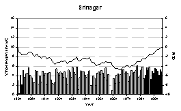


Figure 2 Trend in winter half-year mean temperature at Srinagar from 1894-2000. Panels show temperature series (bars – left axis) with the cumulative departure from the mean plotted as a line (right axis). Separate mean temperature time series are given for each of the months from December to February, with fitted linear trend lines.
Water resources in the region are largely controlled by the availability of summer runoff which is strongly correlated to both winter precipitation and summer temperature. It is found that water resource availability may be forecast accurately 3-months in advance using valley-floor precipitation records due to the strong positive correlation of winter precipitation across the region. The increase in winter precipitation will increase regional water resource availability but, in contrast, summer cooling will reduce summer water availability.
Whilst explanation of these climatic trends remains incomplete, the shared response with the north-west Indian sub-continent suggests a regional or latitudinal effect associated with large scale climatic processes, such as the North Atlantic Oscillation, related to changes in the monsoon circulation.