|
Impacts of climate change on the North West England water resource system |
Published in:
Fowler, H.J. and Kilsby, C.G. 2007. Using regional climate model data to simulate historical and future river flows in northwest England. Climatic Change, 80(3-4), 337-367. [Abstract] Download PDF
Ekström, M., Jones, P.D., Fowler, H.J., Lenderink, G., Buishand, A. and Conway, D. 2007. Regional climate model data used within the SWURVE project. 1: Projected changes in seasonal patterns and estimation of PET. Hydrology and Earth System Sciences, 11(3), 1069-1083. [Abstract] Download PDF
Fowler, H.J., Kilsby, C.G. and Stunell, J. 2007. Modelling the impacts of projected future climate change on water resources in northwest England. Hydrology and Earth System Sciences, 11(3), 1115-1126. [Abstract] Download PDF
This study is the first to use daily RCM data from HadRM3H directly in a hydrological impact study in the UK to examine the vulnerability of water resources in the northwest of the UK to climate change. Therefore, the analysis concentrates on six reservoired catchments (Thirlmere, Haweswater, Stocks, Longdendale, Rivington and Lake Vyrnwy) and two river abstractions (Lune and Lower Dee) in north-west England that are critical water resources within the integrated resource zone of United Utilities.
We aim, firstly, to determine how well combining RCM data with hydrological models predicts the historic daily distribution of annual and seasonal flows in this region. Additionally, we examine the changes to mean annual runoff, seasonality of flows and the frequency of Q5 (the flow exceeded 5% of the time) and Q95 (the flow exceeded 95% of the time) events that can be expected under future climate conditions. We then examine the effect of future climatic change upon the performance of the north-western England Integrated Resource Zone using the Medium-High UKCIP02 climate change scenario (Hulme et al., 2002); based on the A2 SRES emissions scenario.
The northwest England Integrated Resource Zone (IRZ)
The water supply system in northwest England can be classified into complex, linked systems and stand-alone sources. Here, modelling will be confined to the IRZ, which provides 56% of freshwater public supplies to industrial, commercial and domestic customers in the region (Walker, 1998). An interconnection of major aqueducts links sources (impounding reservoirs, river abstractions etc.) with demand centres (Fig. 1). Thus, Thirlmere and Haweswater impounding reservoirs in the Lake District, and sources in Lancashire, the River Lune abstraction and Stocks reservoir, are linked to the Manchester conurbation and central and east Lancashire through the Thirlmere and Haweswater aqueducts. Similarly, Liverpool and the southern part of the region are served by aqueducts from Vyrnwy reservoir and the River Dee in north Wales in addition to groundwater sources. The Rivington aqueduct is bi-directional, enabling water from the rivers Dee and Vyrnwy to be transferred to Greater Manchester and water from Thirlmere and the river Lune to be transferred to the Liverpool area. The Pennine region is served mainly by local sources such as the Longdendale reservoir group backed up by supplies from the Lake District aqueducts. In this study, the 8 largest individual sources which are modelled comprise six impounding reservoirs, Haweswater, Thirlmere, Rivington, Stocks, Longdendale (the largest individual source in the Pennine South group) and Vyrnwy; and abstractions from the rivers Lune and Dee; other inflows derived from these sources are determined using regression relationships.
The eight study catchments, Thirlmere, Haweswater, Stocks, Longdendale, Rivington, Lake Vyrnwy, rivers Lune and Lower Dee are critical water resources within the integrated resource zone of United Utilities, located in the northwest of England. All of the catchments except the Lune are reservoired, and receive rainfall mainly from weather systems from the westerly quadrant. This causes a seasonal flow regime, with the largest runoff during winter and spring and the minimum during summer months. All catchments are located in upland areas and have high annual average rainfall, from ~1200 to ~2700 mm, over 70% of which contributes to runoff in all catchments except the Lower Dee. However, results are given only for three ‘signature’ catchments that capture the characteristic response of other catchments in the same locality or at similar elevations. These are Haweswater (representing Haweswater and Thirlmere; high precipitation, high elevation catchments in the English Lake District), Stocks (representing Stocks, Lake Vyrnwy, and the river Lune; medium elevation, medium precipitation catchments) and the Lower Dee (representing the Lower Dee, Longdendale and Rivington; lower elevation, lower rainfall catchments that tend to be affected by rain-shadowing).
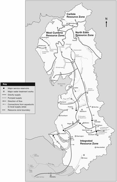
Figure 1 The study area, showing the six north-west reservoired catchments of Thirlmere, Haweswater, Stocks, Longdendale, Rivington and Lake Vyrnwy and the rivers Lune and Dee. The white area denotes the NW integrated resource zone, with the additional water resources of Lake Vyrnwy and the river Dee lying in north Wales to the west.
Using RCM data as inputs to hydrological modelling
Fowler and Kilsby (2007) show that if RCM data are to be used directly as input to hydrologic models, there is a need for bias-correction of all input data series on a monthly basis. Hydrologic simulation is sensitive to biases in the mean and spatial distribution of precipitation and temperature at the monthly level (Wood et al., 2004). In the HadRM3H model control climate for the northwest of England, there are consistent biases in the simulation of mean rainfall, seasonality and variability. Bias-correction is necessary to correct both the absolute magnitude of precipitation amount and the seasonality to observations, and therefore produce realistic runoff series when input to a hydrologic model. However, the bias-correction scheme used here corrects only the mean monthly magnitude, and does not correct for the underestimation of rainfall variability at the daily level in the HadRM3H control scenario. The Wood et al. (2004) ‘quantile-mapping’ bias-correction scheme does address biases in climate model variability. However, the use of this type of correction method assumes that the rainfall distribution will be the same in the future as in the control climate. Using simple monthly mean climate corrections, we were able to provide reasonable estimates of the observed climatic variability within the control climate without resorting to the use of ‘quantile-mapping’ and the assumption that probability distributions used to correct climate model bias will remain stable over time. Therefore, this method was preferred, even though it provided a small underestimate of variability. However, when this correction is made bias-corrected RCM control scenario data can be used to represent observed precipitation and temperature series in northwest England, despite the difference in spatial resolution between the two datasets although using bias-corrected RCM data as input to hydrologic models results in a slight overestimate of observed mean annual runoff at catchments with high mean annual precipitation but matches the observed daily flow distribution well, suggesting that RCM data can be used with some confidence to examine future changes in flow regime
Assessing future changes in flows
Fowler and Kilsby (2007) show that:
(1) the HadRM3H future scenario (2070-2100, SRES A2) indicates increases in winter precipitation of +20 to +30% and summer reductions of up to 50%, but similar change in daily variance;
(2) change in annual rainfall range from slight increases, ~+5%, at the northernmost catchments, to reductions of up to 9% at lower elevation catchments, coupled with an increase in PE throughout the year of +10 to +20%;
(3) annual runoff at Thirlmere and Haweswater increases by ~+3%, but lower elevation catchments show large reductions in mean annual runoff of up to 16% by the 2080s;
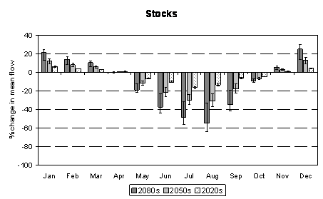
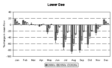
Figure 2 Percentage change in mean monthly streamflow between the HadRM3H control and future scenarios for the 2020s, 2050s and 2080s time-slices. Results shown are for the SRES A2 (UKCIP02 Medium-High) emissions scenario, but uncertainty bounds are given for the SRES A1 and B1 (UKCIP02 High and Low) emissions scenarios.
(4) monthly changes are larger, with summer reductions from -40 to -80% of present flows and largest at lower elevations, and winter runoff increasing by ~+20% (Fig. 2). However, many catchments also show reductions in autumn and spring, which are critical recharge periods. New water resources or management strategies may be needed to counter these effects, which will have a significant impact upon river ecological management;
(5) changes in low and high flows, Q95 and Q5, are substantial. Summer Q95 is projected to decrease by ~-40 to -80%, with the largest increases at lower elevations. Low flows below the present Q95 value are expected to increase in frequency, with consequences for both river ecology and summer water supply abstractions (Fig. 3). High flows are also projected to increase, with the winter Q5 flow increasing in all catchments but with the largest increases of up to 25% in the uplands by the 2080s. This will increase the frequency of winter fluvial flooding and spilling from reservoirs under climate change.
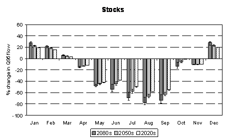
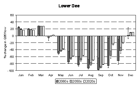
Figure 3 Percentage change in the Q95 flow between the HadRM3H control and future scenarios for the 2020s, 2050s and 2080s time-slices. Results shown are for the SRES A2 (UKCIP02 Medium-High) emissions scenario, but uncertainty bounds are given for the SRES A1 and B1 (UKCIP02 High and Low) emissions scenarios.
The MOSPA Water Resource Model
To examine the performance of the IRZ under climatically changed conditions, the Mospa model was used and the outputs of the water resource system were evaluated with reference to an imposed demand. Mospa is a complex water resources planning model of United Utilities and the UK Environment Agency using components such as demand zones, reservoirs, boreholes, river abstractions and treatment works. These are connected by a network of pipes which move water around the system from the sources to the demand zones via the treatment works. Mospa allows assessment of the performance of the entire IRZ water resource system taking account of restrictions such as abstraction licence conditions, pipe capacity and treatment works. This allows a conjunctive use element (Wood et al., 1997; Lettenmaier et al., 1999) to be defined as, although the reliability, resilience and vulnerability of water sources within a system can be determined on an individual basis, shortages in supply may occur only when shortfalls are concurrent at more than one source. Mospa can be used for several types of run including a basic simulation for a specified period and a yield search in which the model iterates demand on the system to find the maximum yield of the system (i.e. the largest demand on the system that can be met throughout the length of the run without deficits). It can also be used to optimise control rules.
Water resource system behaviour in the IRZ is examined using Mospa for: (a) control climate using bias-corrected RCM data for the ‘baseline’ period 1961-1990, and (b) a future climate scenario (UKCIP02 Medium-High or SRES A2) for the period 2070-2100. In each case two runs were performed: (i) a basic simulation with demand specified as 2224 Ml d-1, and (ii) a yield search, with all resources starting full and based on control rules used by United Utilities in November 2003, a period when the northwest region was suffering from drought conditions. These control rules aim to conserve storage in Haweswater and Thirlmere.
An initial run was carried out using observed inflows for the period 1961-1990 to check that the model control run accurately simulates the observed ‘baseline’ period. The yield obtained, 2313 Ml d-1, is 98% of the control scenario yield, 2358 Ml d-1. Therefore, the control run is deemed to simulate the observed ‘baseline’ adequately. However, yield calculations by United Utilities and the Environment Agency are based on the full record period from 1927-2002 rather than the 30-year period from 1961-1990 used in this study.
For the basic simulation and the yield search, monthly model outputs from both the control and future scenarios were analysed on the basis of overall system yield available and on data on the performance of individual sources. The model outputs included: average end of month storage, total spill and compensation releases, average abstraction and the percentage of total abstraction for individual sources including reservoirs, boreholes and rivers. However, drought water use restrictions are imposed by the model when the combined storage at the Haweswater and Thirlmere reservoirs drops below a certain amount, temporarily reducing the demand to be met.
Impacts on the IRZ system
This study highlights both the utility and flexibility of a conjunctive use water resource system. The contribution of individual sources to the overall yield is highly variable in space; individual sources show increases (decreases) in take of ~80% (~−77%) under the SRES A2 future emissions scenario. The overall effect on system yield is lower, a reduction of only 18.3%, but this has a significant impact on water supply reliability. Nevertheless, the flexibility of the system means that it is still able to meet the modelled demand of 2224 Ml d-1 for the most of the time under this climate change scenario, although this may not include the worst possible drought situation, even without a change in current control rules. However, peak demands may exceed this and the basic simulation runs indicate that the system would fail to meet demand for a few periods under the future climate. However, the flexibility of the system allows the demand to be met, even when the system is very close to its maximum yield, although this flexibility may be compromised under the future scenario. In fact, there is a significant difference in the mechanism controlling maximum yield between the control and future simulations. In the control scenario, the maximum system yield is controlled by the Lake District sources but in the future scenario the controlling influence is the Welsh sources. This suggests that substantial changes in the management of the IRZ water supply system may be essential under climate change. Mitigating the effects of climate change through alternative reservoir operating policies designed to mitigate reservoir system performance losses (Payne et al., 2004) will be investigated in a further study.
However, changes in abstraction licensing conditions, possibly as a result of various EU environmental directives such as the Habitats or Water Framework Directive, may lead to a decrease in take from individual sources that have, for example, a requirement for higher compensation releases or higher “hands off flows” (minimum acceptable flows below which no abstraction is allowed) . Whether these individual changes are likely to be large enough to affect overall yield is, however, uncertain.
Although the IRZ is able to meet modelled demand most of the time under climate change, there is a cost implication of the change in usage of individual sources. In particular, additional pumping from boreholes in the Fylde area (Broughton, Franklaw and Fylde groups) (+67-79%) will be much more expensive than abstracting water from gravity-fed reservoirs. Thus, under future climate change, meeting current demand may be increasingly expensive - an important conclusion for the future of water management in the northwest of England. To investigate the impact on cost further, optimisation runs would be required to examine revised operating rules to optimise cost. This will be the subject of further work.
There are some caveats to this modelling approach. Although it is customary for climate change studies to use 30 year normal periods, such periods do not provide sufficient length of record to represent extreme events. Such events are crucially important in this study, since the droughts of 1995-1996 and 1928 are the standard "design" events for system testing and optimisation. Excluding these events by using 1961-1990 as the normal period causes a major bias in the baseline for the system.
References
Hulme, M., G. J. Jenkins, X. Lu, J. R. Turnpenny, T. D. Mitchell, R. G. Jones, J. Lowe, J. M. Murphy, D. Hassell, P. Boorman, R. McDonald, and S. Hill, Climate Change Scenarios for the United Kingdom: The UKCIP02 Scientific Report, Tyndall Centre for Climate Change Research, School of Environmental Sciences, University of East Anglia, Norwich, UK, 120pp, 2002.
Walker, S., 1998. Sustainable water resources management beyond the 1995-96 drought, Proc. Inst. Civil Eng.-Water, 130, 207-216.
Wood, A.W., Leung, L.R., Sridhar, V., and Lettenmaier, D.P.: 2004, ‘Hydrologic implications of dynamical and statistical approaches to downscaling climate model outputs’, Climatic Change 62, 189-216.