
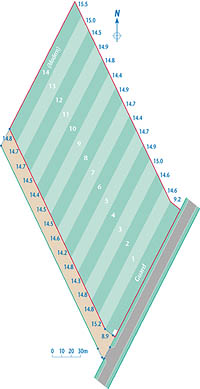
Layout of the Plots
 The
field at Palace Leas was described as old grassland in 1896 and had been
previously manured more generously than many of the other fields on the
farm due to its proximity to the farm buildings. It was decided to place
the most extractive of the experiments on this site; the untreated control
has had hay cut annually since 1896 with no manure or fertiliser applied,
and continues to crop!
The
field at Palace Leas was described as old grassland in 1896 and had been
previously manured more generously than many of the other fields on the
farm due to its proximity to the farm buildings. It was decided to place
the most extractive of the experiments on this site; the untreated control
has had hay cut annually since 1896 with no manure or fertiliser applied,
and continues to crop!
The field was laid out as a series of long parallelogram shaped plots parallel to the public road. The plots were subsequently shortened and other plots, below plot 14, were disestablished. 13 of the original plots remain and the treatments applied to these consist of 5 receiving farmyard manure, either with or without fertiliser, and 8 forming a 23 factorial of all combinations of plus/minus nitrogen, phosphorus and potassium fertilisers. A 14th plot was established in 1976 with inputs of nitrogen, phosphorus and potassium comparable with that of one of the plots treated with farmyard manure.
Aerial Photograph of the Palace Leas plots
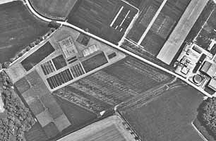
The
field was cultivated at one time, probably during the Napoleonic wars
of 1795-1815 and the ridge and furrow cultivation strips can still be
seen as the stripes running across the plots at an acute angle to the
public road. The variation in vegetation within the plots is also clearly
visible.
![]()
All material © Robert Shiel 2000
Page last updated: